
Thinking about buying near SC 9 in Little River? You have likely heard about drainage upgrades planned along the corridor and wondered what they mean for day-to-day life and long-term value. You want a clear picture of timing, traffic, and flood risk before you commit. In this guide, you will learn what is planned, how to assess a specific property, and the simple steps to protect your purchase. Let’s dive in.
SC 9 drainage plan overview
Public plans and local reporting show SC 9 in Horry County is on the state’s project list for corridor improvements, with drainage work part of the discussion. The South Carolina Department of Transportation’s Ten-Year Plan includes multiple SC 9 segments for safety and improvements in Horry County. You can review those listings on the SCDOT project page for context and updates. SCDOT’s Ten-Year Plan shows SC 9 projects in Horry County.
Horry County also uses state and local funding for drainage. Local news reports that Rural Infrastructure Authority dollars include a Highway 9 drainage project in Little River. For confirmation and timing, check county announcements and meeting materials. See WMBF’s report on RIA-funded drainage projects in Horry County and monitor Horry County news archives.
Why buyers should care
Little River sits close to the Intracoastal Waterway and river inlets. That coastal setting means tidal conditions, heavy rain, and storm surge can affect local drainage and flood risk. Regional planners use coastal elevation data to understand these risks. Explore NOAA’s coastal LiDAR datasets for Horry County to see the kind of data used.
During construction, you may see lane closures, detours, temporary access changes, and construction noise. Local coverage of state bridge and lane closures shows how traffic can be affected in real life. For example, WMBF has reported on swing-bridge maintenance that required temporary closures. See WMBF’s coverage of Little River swing-bridge closures.
After upgrades, you could see better stormwater flow, fewer nuisance floods in key spots, and less road overtopping. That said, drainage changes can shift water patterns if not modeled at the watershed scale. SCDOT and Horry County review permits and design to manage that risk, and final designs guide outcomes.
Flood maps and insurance basics
FEMA flood maps determine lender insurance requirements, not local drainage work alone. Even if nearby upgrades reduce ponding or improve conveyance, your property’s FEMA map status controls whether a lender will require flood insurance. Learn how mapping and elevation certificates work through FEMA and NFIP guidance. Start with the National Flood Insurance Program overview.
If a property is in or near a Special Flood Hazard Area, ask for the seller’s elevation certificate if available. In some cases, owners seek a Letter of Map Change after an elevation survey. That process depends on site elevation and FEMA standards.
How to assess a specific property
Confirm scope and schedule
- Call Horry County Stormwater or Public Works to ask which part of SC 9 is affected, expected timelines, and any public meetings. Watch county project pages for updates. Check the Horry County news archives.
- Review state listings and traffic notices for official details and lane closure alerts. Visit the SCDOT Ten-Year Plan and monitor local coverage like WMBF News.
Review flood risk and insurance
- Look up the address on FEMA’s flood map service and note the map zone. If the home is near a mapped floodplain, consider an elevation certificate and compare insurance quotes early. See the NFIP overview for how elevation and map changes work.
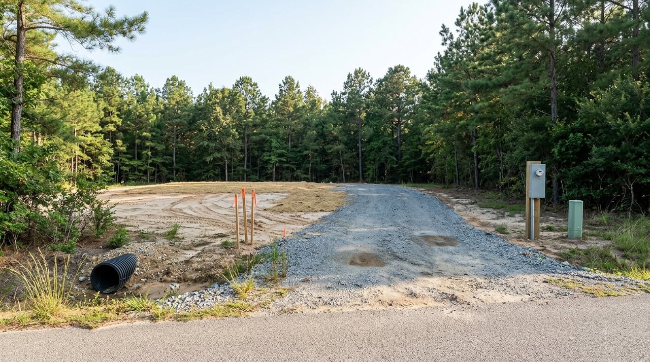
Inspect drainage features
- During your home inspection, ask for a close look at grading, gutters and downspouts, driveway culverts, and any visible ditches or swales. Note signs of standing water after rain and the direction of runoff from neighboring lots. Document private drainage easements on the survey.
Check permits, easements, and tie-ins
- Work inside the SC 9 right of way follows SCDOT standards and permits. Private tie-ins, such as larger driveway culverts, may involve owner costs under DOT policy. Review SCDOT right-of-way and encroachment rules in the South Carolina Code of Regulations portal.
- Ask Horry County Stormwater if the property is on a maintenance list or subject to future improvements. You can locate department contacts through resources like CountyOffice’s Horry County drainage page.
Budget for coverage and costs
- If a lender requires flood insurance, factor that premium into your payment. Get quotes early and ask about steps that might reduce risk over time, such as elevation documentation and proper site grading. Start with the NFIP overview to understand terms.
What to expect during construction
- Commute delays: Plan for lane shifts or short-term closures and allow extra drive time for showings or inspections.
- Driveway access: Confirm how driveway culverts and frontage ditches will be handled during work.
- Noise and staging: Expect work hours, equipment staging, and temporary traffic control near the corridor.
- Communication: Follow SCDOT and Horry County notices and sign up for meeting alerts when available.
Buying near SC 9 now
You can move forward with confidence if you follow a clear due diligence plan. Ask the seller about past drainage issues, prior flood claims, and any notices about public works near the lot. Request available surveys, elevation certificates, and recorded easements. Build time into your offer to confirm insurance quotes and to speak with county or SCDOT contacts if the home fronts SC 9.
If you are building or renovating, align your site plan with local standards. Verify how any private culvert or tie-in must be sized and permitted. Document communication with agencies so you can share accurate updates with your lender and insurer.
Local contacts and resources
- SCDOT project listings and updates: Ten-Year Plan for SC 9 segments in Horry County
- Horry County project news and meetings: Horry County news archives
- Local construction and closure coverage: WMBF News example closure report
- Flood insurance and mapping basics: National Flood Insurance Program overview
- Coastal elevation data context: NOAA coastal LiDAR for Horry County
- County drainage contacts: Horry County drainage resource page
Final thoughts
Drainage upgrades along SC 9 are meant to improve stormwater flow and roadway safety, but the benefits and timelines can vary by location. Your best move is to pair updated agency information with smart property-level checks. With a little structure and the right questions, you can buy near SC 9 with clarity and confidence.
If you want help evaluating flood and drainage considerations during your home search, reach out to Trenette Tucker for disciplined, client-first guidance that keeps you protected from offer to close.
FAQs
Will SC 9 drainage upgrades lower my flood insurance?
- Not automatically. FEMA map status controls lender requirements, and changes usually require elevation documentation and a FEMA map revision or LOMA. See the NFIP overview.
Could the project increase flooding on my lot?
- Projects are designed to reduce risk across the watershed, but flow paths can change. Ask for the project’s drainage report or permit documents through SCDOT or Horry County. Check the SCDOT Ten-Year Plan for project context.
Who pays for culvert or driveway tie-ins?
- SCDOT funds work in the state right of way, and county projects can use county or grant funds. Private tie-ins, such as oversized driveway culverts, may be an owner cost under DOT policy. Review the South Carolina Code of Regulations portal and see WMBF’s report on RIA-funded projects.
How will construction affect daily access near SC 9?
- Expect possible lane closures, detours, and periodic bridge work. Monitor SCDOT notices and local coverage like WMBF News for alerts and schedules.
Where can I verify the current schedule?
- Check Horry County Public Works and Stormwater updates and review the state’s listings. Start with the Horry County news archives and the SCDOT Ten-Year Plan.